Anne’s spring vacation – 7 days – we decided to spend in Utah, courtesy of Tamara’s getting inexpensive tickets for a Delta flight to Salt Lake City. Unfortunately, the flight arrives at midnight. Also the return flight depart at midnight. Hmm… Now the planning part commences. Toma had a lot of info about places in Utah from her dad, and has done a lot of research. The state appears to be filled with large and beautiful National Parks: Arches, Zion, Bryce, Canyonlands (which includes several large separate areas), Capitol Reef. We also plan to go to Monument Valley, which is not a National, but a Navajo Tribal Park, as well as Colorado’s Mesa Verde and Arizona’s Grand Canyon. Initial research showed that going for dinosaur fossils is out of question – too far out of our way north-east. Also it was clear that numerous ghost towns of Utah probably don’t warrant excursions. However, as the planning progressed, we found that even without them we got too much – also added were Dead Horse Point State Park, Gooseneck State Park, Antelope Canyon (though it might be difficult to schedule a tour), Newspaper Rock and Horseshoe Bend. We decided that Grand Canyon is too far out of our way and should be put out for some other trip, so the itinerary looked like
- Salt Lake City – Arches – Dead Horse Point – Island in the Sky
- Mesa Verde – Natural Bridges – Newspaper Rock
- Gooseneck – Monument Valley – Antelope Canyon
- Zion
- Zion – Bryce
- Bryce – Capitol Reef
- Capitol Reef – Salt Lake City
By the way, a nice method to check the ideas turned out to be Google Photo Sphere, integrated into Maps which really helps planning.
I wanted to take a shot (pun intended) at photographing the night sky, which is supposed to be excellent in Utah. For that we decided that time when we arrive from the midnight on should not be wasted on some hotel, but instead spent it driving from Salt Lake City to Arches National Park, near Moab, which is about 4 hours away. At that time we should even have a chance to see the Milky Way. Getting ahead I have to say that it turned out we have not had a clear night sky on this trip 😕
A couple of days before the trip we found out that Cliff Palace of Mesa Verde is closed until the end of May. We decided that it’s not worth going there without the main attraction but our first 2 days look busy enough without it. The weather forecast mentioned some precipitation on the 6th day of the trip but it’s too soon to tell, so we leave it to chance.
We are aware of temperature changes in a continental climate and high elevation of Bryce Canyon, so we pack some layers and small down jackets, as well as some cool lightweight hiking pants that can turn into shorts. Seems like there is a need for a photo backpack! I’ve always been a fan of shoulder bags but carrying additional clothes around would not be convenient. I know that a lot of people do use photo backpacks but I just cannot imagine how to use a camera when just to get it out involves putting down the backpack and so forth… After some research I got a Mindshift Gear Horizon backpack and all I can say – it is simply excellent. A unique and very convenient photo gear access system that works pretty well, good size, fits in a carry-on bin, enough space for a lot of non-photo things. The only complaints I’ve seen about it online is the smallish size of the camera compartment, and I can see how it can be so, especially for telephoto lenses, but this is exactly what my M43 gear is for: travel – 5 lenses (7.5 fisheye, 9-18, 14-42, 20/1.7, 40-150) + small flash, polarizers, IR filter (should’ve used it but didn’t) – fit actually pretty tightly but comfortable and there is enough space to squeeze in Anne’s P&S. The non-photo compartments were large enough to fit 2 extra layers of warm clothes for 3 of us plus snacks, water etc.
For starry night photos (yeah right) and HDR I bought another unique photo accessory: 3Pod tripod. Made by the Adorama brand and available only there, it is unusually compact not only because of the 5 leg section but also because it folds flat. The legs are not folded around the center – it actually does become flat! Combine it with folded length of <35cm – it is really tiny when folded, and fit easily in the side of a small suitcase. Major user complain is that it is not the sturdiest, but, again, it is fine for M43. My main dislike is, actually, the twist locks – not my favorite and there are 4 per leg! No free lunch as they say…
Day 1
Delta flight, in a usual friendly Delta fashion 🙁 did not let us assign the seats until 24 hours before and then all we got are singles. It’s amazing how badly some people want to keep the window and the isle seats with an empty middle, but we finally negotiated in the plane to sit together and off we fly!
Getting a car from Hertz – Nissan Rogue – takes a very short time. We have a GPS in the car, it can prove quite useful when the cell service is spotty (which is almost everywhere we’re gonna go). It’s midnight, we’ll see Salt Lake City on our last day.
Driving south I can sometimes see a silhouette of the mountain chain on the left in the moonlight. Toma and Anne are taking a nap… After getting off the interstate the road soon becomes more curvy, and, clearly, more scenic, although I only see glimpses of the beauty occasionally, when they’re better lighted by rest areas. A lot of hills around, probably green… 2 deer are walking away from the road, illuminated by the headlights, it’s good that they decided not to cross. The drive to Moab is about 4 hours. Getting closer the landscape becomes more arid, also the clouds are getting thicker spelling trouble for my starry sky photo intentions 🤔. We do have a backup plan to spend some of out time this morning, which is a 24-hour Denny’s nearby where we have an early 4:30AM breakfast.
Arches National Park
We get to the park before dawn and approach it a little puzzled. I imagined Arches to be basically flat with natural arches here and there but in front of us is a black wall! Do we have to drive over it? Turned out yes, we do. A serpentine road leads uphill and – voila – we are in Arches National Park illuminated by the moon and occasional cars (no, we are not the only ones here at this hour).

The sunrise promises to be unimpressive and we decide to tackle (no pun intended) the only strenuous hike planned: Delicate Arch. The light is just waking up when we start the hike uphill with Mars-like landscape around. The hills have bands and patches of different colors: yellow, red, greenish, brown, off-white. Anne can’t stop taking photos of the surreal landscape. I take some too, though suspect it’s a little dark for Anne’s camera to get good shots…

This one of her shots looks very good though. Aret we on Mars yet? Where did we park our rental rover?
Walking the Delicate Arch trail takes 2-3 hours roundtrip but not because it is going up (the hike is not steep except maybe in one spot), but mainly because we stop frequently to admire the surroundings. The trip is about 1.5 miles one way with about 500 ft elevation.


The arch itself appears suddenly, and it really is a grandiose view. It is very beautiful and very large, much larger than I expected (about 20m I guess), with red hills and snowy mountains on the background.

Judging by the pictures I saw on the internet one can just take photos from everywhere around it, but, in fact, the approach is a slope that feels steeper than it looks and I see clearly that 1) I should not be changing lenses while walking near the arch and 2) a filter or a lens, or anything or anybody sliding down that slope beyond the arch will be flying down for some time. That fact is exacerbated by a very strong wind…

We stay on the top for awhile (saw a chipmunk running about) and go back. The way back is easier. Anne notices cacti and a couple of rabbits


It took us almost 3 hours for the roundtrip and we are back to our car and only here I’m noticing that the tripod I carried on my wrist is not here anymore 😯 I must have forgotten it on the ground while taking some pictures! Looking for it would take a lot of time and effort, and we only have one day here… If we get to Antelope Canyon it would have to do without a tripod…
Next stop is Fiery Furnace. An amazing formation consisting of tall thin walls and I would love to take a couple of pictures inside, even just from the edge. It is however prohibited to hike in (there are no trails) and the signs threatening us with fines are there to be more impressive. Toma doesn’t want to spoil the vacation plus we don’t really have too much time to spend. Alright, we proceed. Looking back, we should’ve spent some time there…


Next stop is The Windows – a two arches in one large wall, also featuring a lot of interesting formations nearby. We take a hike around them, the wind is raging, which spoils the effect a bit for Toma and, especially, Anne. I mean, sometimes it really makes it difficult for her to stay on the trail. Toma says, “Now I really understand how these stones got eroded so much. A little more and we ourselves are going to start eroding.”


This one I think is a hockey team.

My hat is trying hard to get away to the prairie, and several times almost succeeds. That’s it, from now on it shall stay in the car, I decide after another chase. Fortunately I convinced Tamara to purchase a nice hiking hat before the trip. The sun is very forgiving so far and she graciously makes it mine. Another interesting feature of the landscape is a very fine sand. I don’t think we’ve seen such a fine sand as this red powder. We wouldn’t mind it at all if we didn’t feel it by now on our teeth 🙂.
Double Arch is huge – pictures don’t do it justice, but you can see the tiny figures of people climbing the slope…

Balancing Stone. It also doesn’t look that large on the photo until you see the people and the tree around…

The wind is not letting up, we also see a small cloud with rain coming out it nearby and we feel a couple of drops while Anne is conversing with a park ranger. After taking in the panoramas for a bit more we are heading back to the beginning of the park. The surroundings are… surreal…


We have not seen the structures near the entrance in daylight, and they are very impressive! Again, photographs do not convey just how large all these figures really are.

The trees in this photo of Sheep Rock are not large, but they’re trees – maybe 10-15 feet high?

Driving up to the trail head of Park Avenue. This is a classic view – truly majestic!

We suspect the view from the Park Avenue trail is not as impressive as from atop. Plus the rain starts to drip and it’s almost 2PM – time for lunch, considering that we had a breakfast at 4:30AM and had very little sleep. I only slept for an hour or so on the plane.
Moab is located a very short drive off Arches. Going through the town we see that the traffic lights are not working on the main street, though traffic is not that bad. Choosing a restaurant for awhile, we finally stop at a diner. “Three people please,” – we say. “Sorry, we can’t seat you, our power is out,” – we hear – “We can only sell you ice-cream🙃.” Well, let’s go to another restaurant. – “Oh, by the way, the whole town is out of power!”
Just great! Subway wouldn’t sell us sandwiches either – not allowed when the power is out😦. We decide to just get some food at 711 and eat it in our hotel room. When did you lose the power, we ask the 711 guy? – About 15-20min ago. Just our luck! Toma picks up some turkey and bread, I – water and a veggie dip. We are at the hotel. “I’m sorry, but I can’t check you in” – we hear – “The computers are down. Also our check-in time is 3PM and it is only 2:40.” He did offer the hotel breakfast area to guests to sit down and have a bite. There are also restrooms on the 1st floor, but the light in them doesn’t work! Fortunately I brought a nice compact head light to use in the dark… for photographing stars… so there is an occasion to use it after all 😀. Afterwards we talked with several people in Utah trying to figure out whether the wind blowing out the power is just an everyday occurrence or an exception, but they are a little elusive on the point, something like, – “No, it almost never happens.” – “When do you think they can fix it?” – “Oh, it usually takes 3-4 hours to come back. “😅
We have some sandwiches and think what to do next. The plan was to visit Dead Horse Point State Park today but the fuel level is questionable and, of course, all gas stations are helpless. The repairs are projected to be done by 5:30PM but who knows… We decide to have faith in the electrical company and wait. Toma and Anne are talking, I’m checking the photos in-camera. And then – behold – there is light! They turned it on shortly after 3PM, so the total outage must have been, maybe, 1.5 hours max. Hurrah! We fill the gas tank and proceed to
Dead Horse Point State Park
Dead Horse Point State Park is located just off Canyonlands National Park, and, basically, is a part of the same group of canyons. The only reason I see that it’s separate is that, in fact, it was established 5 years before Canyonlands. The Point is separated from the wider area by a narrow neck (30 yards, though it seems smaller) and said to have been used by cowboys to capture mustangs.

A curious fact: Thelma and Louise jumping off Grand Canyon in the film were actually jumping off Dead Horse Point (into the same Colorado River). That was one of the reason we decided to postpone our Grand Canyon visit: if Dead Horse Point was good enough for the movie it should be good enough for us. A view is very impressive indeed.


It also offers a great view of La Sal Mountains (provided you’ve a telephoto lens lying around). We saw them from Arches but in the morning the sun was behind the mountains. This time they’re nicely lit. Photo by A. Barshay

Someone made of stone is “lurking around”. We spend some time finding more shapes…

We end our sightseeing day and drive to Moab. One of the slopes at the road side near the town has an area, maybe 100ft high and about as wide, of this fine red sand. Some people are climbing up with a clear intention to do some sledding! And on that sand they can do it.
A sushi place with nice reviews in Moad is packed plus do we want sushi after a power outage? We end up to have a dinner at that diner we tried first (not very good). The long day is over, we go to sleep early.
Day 2
Island in the Sky
Island in the Sky is the northern part of Canyonlands National Park and includes canyons of Colorado and Green Rivers that join together in a middle of Canyonlands.


The most impressive spot of Island in the Sky is, probably, Mesa Arch, a natural arch overlooking a great panorama of canyons and mountains.


There are many overlook stops and, although I guess they are not as graceful as the Dead Horse Point, beautiful and majestic nonetheless.
The weather today is very nice and sunny and the wind, though quite noticeable, is not as strong as yesterday.

Toma discovers a strong interest in geology, and there is plenty of information in the paper guides and on multiple tableau in the park. This tendency will continue throughout the trip, so now we have an official geologist of the family. Toma also tries to get Anne and me to research the multiple layers of stone that are clearly visible in vertical slopes. She has some success though I’m much distracted by the abundant photo opportunities.


The view of La Sal Mountains is as good, since we are, after all, about 5 miles away from Deal Horse Point, if measured straight…

Somebody stepped into the dirt 😁

This time the lunch will be in Subway (one of Anne’s favorites and our junk food preference).
Now we are turning south, towards Newspaper Rock and Natural Bridges but make brief stops on the way to looks at some interesting stones, such as this curious “creature”

Newspaper Rock State Historic Monument
Newspaper Rock is, well, a rather large rock with A LOT of petroglyphs on it. It’s basically, covered in pertroglyphs, apparently made over a large period of time.

after looking at it for a bit we continue our journey to
Natural Bridges National Monument
It’s rather close to sunset time. We initially thought, and that how it looked like on the maps, that the bridges are just there to see, but Natural Bridges visit actually involves significant amount of hiking and we decide to go on one of the trails. I suspect a part of it for Toma and Anne was curiosity: it involves climbing ladders! All those rocky slopes worry me, as they did in a couple of places in Arches. Definitely looks like one wrong step will send one flying down. I know Toma is also concerned about Anne, judging by her frequent warnings. Of course we were just being overprotective because neither of us 3 is used to this kind of hikes, Anne did just fine.
The weather is still great though getting a bit chilly. The views are very nice. Here is what appears to be an enormous stone hot dog

The bridges are very interesting but the view from above in this case is not the best direction, they would look better looming over the sky. Alas, the hikes to the bottom are challenging and would take a long time. We walk the trail until a nice observation point


At another site there are ruins of Ancestral Puebloan houses in the cliff, that’s worth a hike


By the time we finish Anne is pretty tired. Tonight we’ll drive to the town of Bluff and have dinner at a hotel restaurant, all planned ahead.
Entering Bluff the road goes through really beautiful weathered red cliffs. Right after is a restaurant surrounded by red natural figurines, the ones on the left are Twin Rocks.

Hotel Desert Rose as well the room itself is in “rustic” style but polished at the same time, with numerous decorative pillows on the bed. I’m building a wall out of them 🙂. The restaurant on premises is also very nice.
Day 3
Our room faces the back of the new hotel building with the cliff view. In the morning we discover, to the endless excitement of Anne, that the area to the back is a grazing ground for a lot of cows! We watch them from our terrace.

After breakfast we start driving towards Monument Valley, with a stop on the way.
Passing a beautiful area called simply “Valley of the Gods”. .. The landscape in south-east Utah is amazing – looks like there could be a beautiful hike at every mile. The GPS we got from Hertz is funny. Instead of just tell us the road numbers (which are on the road signs by the way) it tells us in a mysterious voice: “Make a right turn to the Trail of the Ancients.” There seems to be many roads in Utah that have this sort of names too. We fully expected our GPS to start some shaman singing at some point…

Gooseneck State Park
The park is just a view point to the beautiful curves of San Juan River. It is absolutely worth stopping by though. I’m trying to get all 3 curves into a picture – it’s very hard and what makes it harder is… the wind!!! I didn’t know it could be stronger than on the 1st day but it definitely seems to be, this time not only Anne but Toma and me both are trying to keep steady… This is the best I could do with a fisheye lens 🙁
Nearby place is called Mexican Hat. Arguments about the origin of this name stop when we see this along the road

And now – onward to
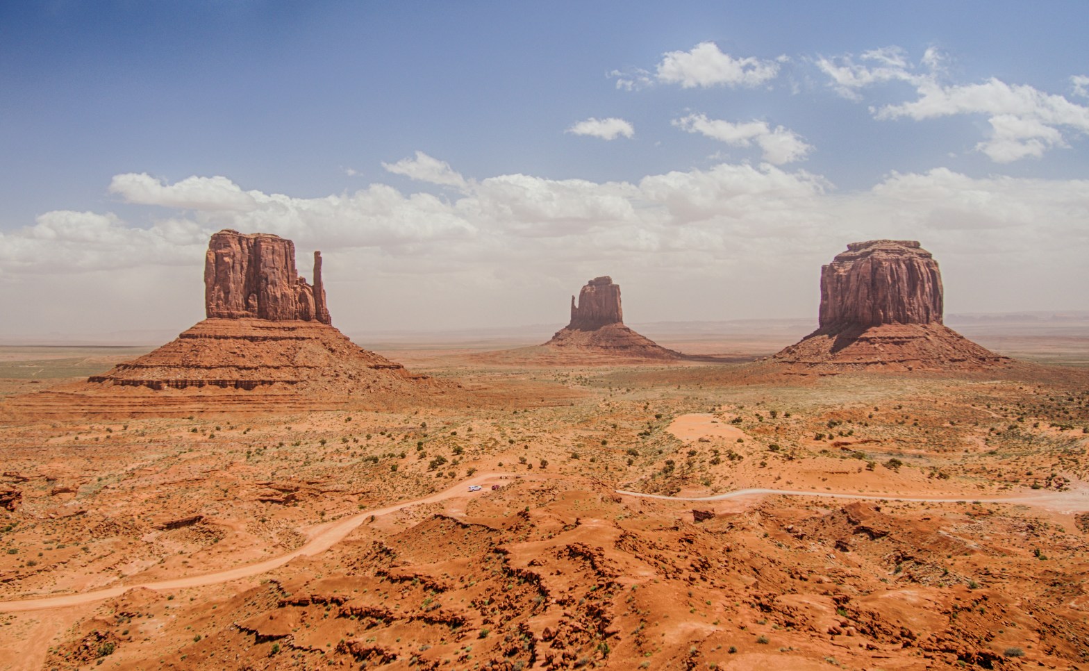
Monument Valley Navajo Tribal Park
which is located on the border of Utah and Arizona. Officially, turns out, Monument Valley is a large area around the park, and deservingly so, since we start seeing interesting natural monuments long before we arrive. Thanks to the flat landscape we see our destination from afar.

The nice thing about the park is that there is a dirt road to drive around, so long hikes are not necessary to see the panoramic views from different angles. The wind is very strong and once again we’re trying to keep sand out of our mouths and eyes. By now we know we’ll get it in our shoes and socks.

A Navajo guy offers a photo op on a horse, $5 to pose of the edge of the nearby cliff! Anne had an eye on this horse since we passed it in the car. Sitting on it – even better! I can’t miss taking this picture either. I’m a bit uneasy about very close proximity of the stallion to the cliff edge, but the horse keeps very very still.


We try Navajo fried bread, it pretty nice, tastes like a cheburek without meat. We continue on, with wide views in front of us.


Back at Visitor Center, another look at the famous mittens


The wind is picking up. Literally, it is picking up sand!

We have a lunch at the only place on the premises (rather terrible). I decide to call and try to book a tour at Antelope Canyon, which is on our way, but I read that it may get crowded and tours do get sold out. A convenient place to get a tour of Upper Canyon is Adventurous Antelope Canyon Tours. My call this morning wasn’t picked up but now a lady answers. “Have you notice the wind today?” – she says. “Why yes I have”. “There is lot of sand coming down into the canyon from above. We can take you on a tour but you have to be, basically, covered from head to toe except the eyes, sort of like a ninja.” I’m trying to imagine Anne and Toma dressed like ninjas going into Antelope Canyon… I’m not sure… “I’ll call you back.” Whatever will be, will be, we’ll come to that place and see what the situation is, maybe it’s going to be better there. The sandstorm here is getting worse though and the views from the road are murky.

This is how the road looked sometimes

We are driving west with the intention of getting to Springdale (near Zion National Park) for the night. However, the way lies close to several interesting spots that we’d like to visit. The road is long and somewhat boring, Toma and Anne are napping. Some passing clouds bring rain, which is good, since the car is covered in fine sand. Another passing cloud bring a little snow 😮, which is wholly unexpected and does not fit my preconception of Arizona!
Several miles before Page, AZ lies
Upper Antelope Canyon
There are two Antelope canyons: Upper and Lower, both slot canyons. Upper Antelope is a famous photo location, although many people claim that Lower one is actually more interesting. Partially what makes Upper Canyon famous is the rays of light that can be photographed during certain hours. It is now about 4:30PM and, unfortunately, we have no chance of seeing them, but it’s too late to change our plans or look for other tour locations. When we arrive to the place the dress code is still on, a rain is starting to drip, the wind is rather strong, and I’m told it’s actually very cold inside the canyon. The time for the last tour is about now so we need to make a decision. Toma says: just go by yourself, we are ok to wait in the car. Thank you, darling, for suggesting it and agreeing to wait for projected 1.5 hours so I can visit the wonder! I spend $2 on a mandatory bandana, put on another layer and a hat and go. Turns out I’m the only person on the tour.
The canyon turned out to be shorter than I expected, it’s basically a crack across a narrow long hill. Inside however… let’s just say the place met my expectations. The curves and the colors! Amazingly, the wind quieted down and there was only a couple times when we got sprinkled by sand from above.


Looks like a head of a dog.

An owl nest at the entrance, with a baby in it

The tour took a little less than an hour, shorter than expected, probably because I was the only one and didn’t have a tripod to fiddle with (wish I did 🙁)
On the way back the driver notices a roadrunner. Looks like he (the roadrunner) got the dinner question solved.

All excited about the tour, I make my way to the car. Next stop is a place a little south of Page, AZ called
Horseshoe Bend
which is a bend of Colorado River. Judging by google maps it should be right near the highway, but it turns out that, while it is not very far from it, we have to walk over a rather steep hill to get there. That does not fit in Anne’s plans and she let’s the world know… so getting over that hill proves longer than it could have been, but in the end the view is gorgeous. A perfect shape and a perfect color. A rather famous view too…

Upstream on the other side of Page is Glen Canyon Dam, the one that created Lake Powell. There is a point with a view of the dam and a nice view of the river.


Driving towards Zion National Park the landscape changes – no more patchy grass that makes ground look like cheetah’s fur from afar, the trees become more frequent and more, well, tree-like 🙂. The forecast today is rainy but tomorrow should be nice. The day after tomorrow, however, looks rainy after lunch, so we intend to really go over the places we’re interested in at Zion tomorrow and maybe get to Bryce the morning after. While driving through Kanab we see a real snow, fur trees are standing in white… Temperature outside is 37F, which makes us a bit worried, but getting down to the bottom of Zion Canyon the snow turns to rain and 37 degrees to 45. The road is beautiful and winding, also very wet and slippery, which makes us slow down a lot.

By the time we’re in Springdale it’s late, wet and cold, and we’re glad to get to the hotel at last.
Day 4
Zion National Park
The weather is beautiful, albeit a bit chilly, and we have out winter jackets on. Our hotel is right near the park entrance, so we leave the car behind, pack snacks and water into the backpack and off we go! First thing first – just like in Arches, we’ll start with the most demanding hike on our list – Scout’s Lookout. Scout’s Lookout is the stopping point on the way to the really cool one – Angels Landing. It is, basically, Angels Landing sans that steep narrow climb at the end. Also, instead of the panoramic view, it affords a view to the side of the cliff. The trail is about 2 miles one way with 1100 feet elevation, so it is not short by any means, and kind of steep in several places. Once certain elevation is gained the view becomes more expansive

and we see some wildlife around, particularly in the form of a large red squirrel

The first part of the hike is getting up, and Anne gets tired by the initial climb, but we push forward (upward?) and enter a narrow Refrigerator Canyon, until finally we reach the annoying Walter’s Wiggles, 21 steep short switchbacks. On the map you don’t see this kind of features – these switchbacks look like a tiny dot! This is not a pleasant surprise, we feel a bit tired, but gotta go on.

Turns out the switchbacks are the last effort before Scout’s Lookout. I know the view doesn’t compare to the nearby Angels Landing but it is very nice indeed, with a blue sly, the river below, and the mountains with occasional snow caps…

Curiously enough, we don’t feel the “cliffside anxiety” here much, although the cliffs are steeper and the way down is longer 🙃. I guess we just got used to the rocks, or maybe climbing up makes the perception different from approaching an abyss from the top. Anne is making her way swiftly on the slope to find a nice place to sit and we have some rest, and I go hunting for pictures…


Notice that the winter clothes we had on in the morning are all gone… to the backpack.

Scout’s Lookout is a nice resting area for people going to and from popular Angels Landing, and local chipmunks are taking full advantage of snack opportunities, going between people’s feet and through they’re backpacks. Those guys are everywhere!


We see people going up to Angels Landing. It doesn’t look too bad, but of course judging an ascent is always easier from below 🙂. It is amazing how narrow this part of the mountain is really. I wonder how all these people fit on the top, I would hate to stand on the slope waiting for people to finish…

The way back is (obviously) easier and we have more opportunities to enjoy the surroundings.
Lunch in the local cafe (since our intent is to see everything today, while weather cooperates, we won’t go to the restaurant), a little rest on a pleasant lawn with the view of the surrounding mountains, and we’re off to the next attraction, Emerald Pools. There are three of them: Lower and Upper Emerald Pools are waterfalls and the Middle one is a pool. Today none of them is really emerald, but they are really water full after yesterday rains. The hike is not particularly long distance, but at times pretty steep.
The Lower pool is very beautiful


Middle pool doesn’t invoke awe, but it’s a nice, sort of quiet and pensive place.

The walk to the Upper pool is steep and rocky. The waterfall is located such that all the air and splatter coming down are reflecting off the mountain wall. Today the fall is really strong, so whoever approaches the pool even from afar gets a nice cold shower! Toma and Anne do get close enough to pose for the picture, but then retire a little bit and admire the view from a little further away. There is a large boulder that is definitely large enough for a person to hide behind, although I get a bit wet before reaching it. This boulder gives me a chance to prepare the camera (fisheye lens are necessary) and quickly step from it and take a picture. I try it 5-10 times but only one shot I made did not feature water droplets on the lens (of course the depth-of-field of fisheye lens shows them distinctly).


Down from Emerald Pools, the time is ticking towards evening. We do, however, have enough time for River Walk, an easy and very pleasant hike on the bank of Virgin River towards Zion Narrows. On some days, we’ve read, one can actually walk on the dry bottom of the river a little bit inside the Narrows. Looking back at today’s day we agree that it was the most, strictly speaking, pleasant day of our trip. The nature is gorgeous, the wind is calm, the mountains are majestic and the air is fresh. A conclusion of a truly enjoyable day! The weather has been by far the most enjoyable, and we have great time walking. We take out a warm layer of clothing from the backpack – it did start getting cooler.


We reach the Narrows and, predictably, the river is full and there is no way to walk past the trail. But we can certainly enjoy the views from the trail end, contemplate and take in the surroundings.


The day ends, we get the last glimpse of the park on the way back.


Dinner in the nearby Thai restaurant (turned out to be pretty good) and back to the hotel, through an unpleasantly surprising drizzle. The rain was not in the forecast for today, although, of course, it is nice that it did not come earlier.
Day 5
OK, we have a problem with the weather forecast – now it shows not only snow for Bryce tomorrow, but also rain today! Precipitation is also in the forecast for other nearby attractions. We decide to run away from it, and Toma has a fresh idea – run south! On the table are the options of going to Las Vegas – surprisingly only 2.5 hours from Springdale, or Grand Canyon – 4.5 hours to the South Rim (North Rim is still closed for the winter). After some deliberation she leaves it up to me and I choose Grand Canyon. It fits better into our trip, we are better equipped for it, and Las Vegas is more likely to warrant a dedicated trip. So, without further adieu, or rather, with a warm “adieu” to Zion National Park, we’re on our way to Grand Canyon. I can’t find my Kindle- either I dropped it on the way from the restaurant (it was raining and dark and we were running a bit) or, if it’s somewhere in the room, I just can’t find it. If there is a question why we had our e-book in a restarant, the answer of course is that Anne doesn’t eat anything in a restaurant without it. Since my Kindle is on what Anne used to read Harry Potter for the umpteenth time, she is upset. This is already the second piece of equipment (together with the tripod) that I lost in Utah 😒.
The drive is long and, generally, uneventful, although we do pass some amazing views, including going nearby
Vermilion Cliffs

and trough
Marble Canyon.

By the time we reach
Grand Canyon
it is lunch time. We have some sandwiches and snacks for lunch, watch a short movie about the canyon and then, finally, walk about to see some views


I don’t know what’s with these blooming clouds but it’s starting to rain again! It’s not light either, we have to seek shelter, fortunately Yavapai Museum is right there and we have some time (it took about an hour to fully pass) to look through the books, listen and talk to a park ranger and look out of the panoramic windows at the canyon. I was lucky enough to see a California Condor flying some distance away (wouldn’t have recognized it without the movie we saw at Visitor Center). Anne has a chance to pick a book to replace Harry Potter for the duration of our journey and, to our surprise, she picks “Over the Edge: Death in Grand Canyon” – a more than 700 pages opus, inscribed as “Gripping accounts of all known fatal mishaps in the most famous of the World’s Natural Wonders.” Charming! It even has a skeleton on the cover. The book will serve as an object for many jokes afterwards: “Be careful near the edge if you don’t want a chapter in that book…”
But, either way, our repose is not unfruitful, as we have learned various things about Grand Canyon and its history. Among more current of them is that the weather promises to bring thunderstorms tomorrow. We decide that the afternoon will be a bit rushed and we have to move in a more directed fashion. We drive to the western part of the park to complete it today and leave the eastern part for tomorrow morning, be it as rainy as it may.


Raven is sitting on a handle, this should be a good shot when it flies, and it is:

There is an opinion that Grand Canyon is “too grand” if you will, that the vastness hides the beauty of the details, and though to some extend I think it’s true, the layers of patterns are not to be missed and the details is something a telephoto lens can help with…


Rain catches us periodically so our umbrellas see some use.
We see a family of Mule deer on the way to the hotel, there are 6-8 of them and we drive slowly past. Very cute!
We also see a pair of Elks from the road. I did not stop in time, and didn’t want to go back on a road without a shoulder in the rain, but, thinking back, I should have. They were very tall and beautiful, although still lacking the antlers.
I already changed the hotel reservation in Bryce and reserved a room in Best Western Premier Squire Inn in Grand Canyon. This hotel is definitely the fanciest Best Western we’ve been to, beautifully arranged. The restaurant looks very nice too though it takes forever to get food here.
Day 6
Grand Canyon National Park
Yesterday we saw the overlooks in the central and western parts of the park, today we’ll see the ones in the eastern part, finishing at Desert View, incidentally the closest to the park’s exit. Well, let’s see what kind of thunderstorms are awaiting us in Grand Canyon today. The morning looks very nice though a bit chilly, in the lower forties. But, go figure, there is a cloud nearby that looks like it’s got potential. Closer to the canyon it actually starts snowing. The snow is unusual, not of snowflakes but of lumps about 2-7mm in diameter, though not exactly hail – the lumps are not made of ice, but of snow, they are soft and very light.

Some snow is accumulating to our amusement and bewilderment. We are in Arizona for crying out loud, where everybody including us is supposed to be frying under the merciless sun!

Our expedition becomes quite curious – we arrive at an overlook and after about 10-15 min the cloud catches up with us and it starts snowing. I can’t say it’s not working, maybe it’s the nature’s way of not only making sure we see Grand Canyon (by routing us here with rain and snow in Bryce) but also making sure we don’t stay too long in one place and miss other things. Either way, the looks are quite beautiful, with the clouds hanging low above the canyon.


We leave a little after noon. The drive to Bryce is about 5 hours. The thing about driving around Colorado plateau is one won’t beat Google Maps predictions like one does in New Jersey or Upstate New York. Speed limit is high and there is a lot of spots I have to slow down below the limit to adjust to the curves.
We stop in Page, where we’ve been before. We have a lunch in an American restaurant, which served pretty nice sandwiches and, probably, the best onion rings I’ve had, not that I’ve had many… Heading out we see another cloud that looks like a real thunderstorm. We are passing Glen Canyon Dam again, and this time we see a little side road that leads to a beautiful overlook of Lake Powell.


The sight is very impressive but we only have 5-10 min. I make the last photographs with the first drops of rain and we just roll onto the highway when we get under this one

I don’t know, from our experience it seems that it is, basically, always raining or snowing at several places around Colorado plateau, they might as well fix the forecast as “rain every day” and be largely correct, at least at the end of April. The only two days when we didn’t see any rain or snow were the ones we stayed in one place. Another interesting thing about the clouds around here is how low they are. They really do seem to touch the ground sometimes. Maybe this is because we are on the top of the plateau, in fact we are close to the western edge of it, so maybe these are regular thunderclouds which just happen to be at the same elevation as we.
Approaching Bryce the nature turns from arid to moderate again, and we get another alert from the car about the temperature outside. For some reason it’s configured to raise an alert if the temperature drops below 38F. Getting closer to our destination the snow starts. No, not the same snow that we saw in Arizona. This is a real blizzard, thick as ice cream, the type of weather when one leaves the car at home… Going through Red Canyon, part of Dixie National Forest, the view is absolutely gorgeous with pine trees and snowfall and natural monuments!


Approaching
Bryce Canyon National Park
the snow turn lighter. I’d love to see Bryce Canyon in a snow and insist on driving directly to the park, but a guy there claims there is really nothing to see because of a very poor visibility. Frankly, looking back I think there are a couple places in the park that would’ve looked great during a heavy snowfall, but we probably would’ve spent a good hour looking for them and it was past 7PM and getting a little dark. As it was, we decided to go to the hotel.
Driving out of the park we are passing several Mule deer on our side of the road and this time we stop, as quietly as possible, and I get the camera out. There are 5 of them nearby, maybe 15 meters away and they’re pretty much unafraid of me. Turns out, a good way to make a picture of an unconcerned deer is step on a little branch – the deer looks at me, get stiff for 5-10 sec, and then go on with the chewing.


Bryce is located almost 8000ft (2.5km) above sea level. Toma has stomach ache and I feel a little nauseous, either we got it from the previous meal or the altitude effect (inet claims that both are potential symptoms), so today we decide to skip dinner altogether, have some healthy snacks and drink some tea and water. Not Anne’s dinner of choice but today she has to comply.
Day 7
Bryce Canyon National Park
Breakfast buffet is just what we need after our dinner the night before!
A large bird is busy just outside the hotel back door. A further research reveals it to be a Yellow-headed Blackbird.

After breakfast – check out and off to the park. Today is our very last day around here and we are going to Bryce Canyon, hell or high water. Fortunately, the morning looks cheerful and the sun is in the sky and the snow is on the ground and on the pine trees. It’s 34F 😮 and we have all our winter attire on. Toma even puts on her winter hat, something she rarely does during NY winter. She is a still amazed at the yesterday’s blizzard and today’s snowy forest. “Where have I brought you guys!? It’s a winter vacation!” – she says. Anne answers immediately, “Yes, thank you! I spend all my winter vacation on test preparation courses, now finally I have my winter vacation!” This makes our mood even better.

Bryce Canyon Amphitheater is breathtaking. Yes, we knew about the hoodoos, but what’s amazing is not just shapes and the sweeping panorama – it is the lines and the colors! With the sun not yet in zenith some of the figurines look like they’re glowing…


A guy at Inspiration Point mumbles, “You just can’t take a bad picture here”. And he is absolutely right, the only place I’ve seen comparable is Antelope Canyon. Some shapes resemble a column of soldiers, some – a mediaeval castle wall…


It’s clear that we will not hike down the canyon today – the trails are very slippery. We visit all the views around Amphitheater and intend to turn to the exit when Toma makes a mapping discovery – the road continues further south with many more overlooks to see, including Rainbow Point, the highest point of Bryce National Park at 9000ft (2.75km) above see level! Speaking of altitude, while neither of us has any problem from yesterday evening I do experience a curious sensation – every time I hold my breath for a photo shot for several seconds I have to breathe rapidly a bit afterwards…
While they don’t have the hoodoos gathered in such great quantities, further overlooks are also great with never-ending variety of shapes. Bryce Canyon yielded the most photographs from this trip, and they were the hardest to discard any; so it really does look like we saved the best for last. Anne grumbled a little about winter clothing, but she admits this is an extremely beautiful place.


The combination of reddish ground and green fur trees looks fabulous.

We are in Utah after all, so, of course, we see a nice cloud nearby and, sure enough, it starts snowing! Not an unpleasant snow though – it’s dry, soft and very slight.
On the way to the interstate we pass Red Canyon, now without the snowfall, and make a short stop.


Route 15
Nothing lasts forever and we have to wrap up our trip. Google map claims it is a 6.5 hour drive to Salt Lake City and I know by now not to treat its estimates lightly. We have a lunch and start on our way.
The mountains I saw a shadow of on our night drive from Salt Lake City are now in full view from Route 15. Toma has the camera and can’t stop using it.


We pass through a thunderstorm (like anybody doubted that)


There are three accidents on our way to Salt Lake City and the drive takes about 7.5 hours, and it’s almost dark. We drop in at Cheesecake Factory – there is about 50 min wait – and while we wait for our turn to eat we walk around Temple Square. It is very clean, abundant with tulips and other flowers, Anne is running around excited, she is making pictures until her camera is out of juice. These photos are made by her:


We spend about half an hour on it and return to the restaurant. There is still some time before our flight so we come back after dinner to make a couple of more shots.

In a true Delta fashion, seating arrangement is not available at all for our 12:40AM return flight, so we’d like to have a bit of time to pick the seats. Turns our the airline simply distributes them itself. Ours are 3 together – yay (?) – turn out to be on the very last row, right across the isle from the restroom and just a wall away from stewardesses making coffee. Looks like we won’t get much sleep on the way back either 😟. Well, one of us actually does – Anne sleeps like a baby throughout the take off, flight and landing. Happy return! Now the work starts as I have about 1700 shots to go through, and that’s after already having discarded the obvious duplicates and fails, and it doesn’t account for the pictures made by Anne and some smartphone snaps. Our itinerary ended up looking a bit different from the plan:
- Salt Lake City – Arches – Dead Horse Point
- Island in the Sky – Newspaper Rock – Natural Bridges
- Gooseneck – Monument Valley – Antelope Canyon
- Zion
- drive and Grand Canyon
- Grand Canyon and drive
- Bryce – Salt Lake City
Photographically speaking, this turned out to be the most productive trip thus far for us – about 700 pictures after processing, all here. Although I fully expected ultrawide and fisheye lenses to be the tools of choice, most of the photos were made with el cheapos 14-42 and 40-150, which explains the excessive chromatic aberrations in many shots. Maybe I need to do something about it…
Well, our outdoor vacation is over. We managed to visit a lot of beautiful places on each day of it, although we’ve also seen rain, snow and windstorms, and on one day, all three! What we have not seen is that of which everybody forewarned us: excessive heat and dehydration 🙂. As such we declare this expedition a big success! A popular poll of my family opinions revealed Zion and Bryce Canyon as the crowd favorites. Now we have to plan a return trip 🙃.
