for part one of our trip look here
Day 7
Bay of Fundy
That’s right, we are back to our favorite bay, where the weather in the summer is so nice. Yes, it is still nice today, with the rains gone overnight. We are not going to Fundy National Park, but we are going to visit a place called St. Martins Sea Caves featuring… well, sea caves near the town of St. Martins… and drive a Fundy Trail Parkway, a road along the shores of Bay of Fundy, that should feature nice outlooks. I’m not sure how far we’ll drive along it, as I found the place simply on google maps, we’ll see.
The sea caves are quite large. This is morning-ish time, which means low-ish tide, and the caves are exposed. People are walking in and out.


We walk along the pebbles for awhile and continue towards Fundy Trail Parkway, which, as it turns out, is a paid road. After visiting it we understand why. These outlooks, especially towards the end of it, are simply the best views of Bay of Fundy, well, that we’ve seen in our limited experience.


I thought “Fundy Trail Parkway” is a road, but it turned out to be more like a park of a very elongated shape along the coast, with a road going through it. Besides outlooks there are frequent trails going down to the shore and some forest trails. This one leads to a small waterfall.

Here is a short instructional video on how to gracefully pose for a waterfall photo while shooing off the insects.
Like a good park, it also has a visitor center, where we make a bathroom stop. The surroundings are very picturesque. I’m making some flower photos when Toma says: “Roma, you’ve got to see this. Come on, look at it!” It turns out to be a large moth (I believe Columbia Silkmoth) sitting on a visitor center’s wall. It is dark and colorful. Cannot not photograph it.


A lady from the visitor center comments: “Oh, there is a bunch of them on the other side.” Really? No way! The other side turns out to be the shady side of the building without any doors. Probably that’s why it is serving as a relaxation place to dozens of beautiful moths of several kinds, ranging from small ones less than an inch to a huge gorgeous green Luna Moth about 6 inches long.


This stop certainly took a bit longer time than intended, but finally we continue.
Another stop has… maybe not precisely a visitor center, but a small wooden shack hosted by a volunteer, with some info about the shores, rocks and minerals, and marine wildlife.

Another pebble (and boulder) beach is there, another pebble hunt is in order.


As I mentioned, as good as the views are, the best ones are from the farthest outlooks of the park. While the road continues after them, it turns inland, and while it’s possible that some great outlooks can be reached there, we don’t really have time for more explorations. We turn back.


We are back to Sea Caves, time for a high tide. Predictably, the caves are flooded. At least they are not back-lighted, like in the morning. The sun from aside makes a much better view.


It is also time for “linner”, which we have in the nearby Cave Restaurant. Another lobster roll, this time without onions, but with celery. Also good.
Our path leads to Saint John but I remember seeing a spot on google maps called modestly “Quaco Head – UNESCO Fundy Biosphere Reserve Amazing Place”. Amazing or not, I think we can all agree that we must see a place called Quaco Head if we are nearby. I mean, this name is just too good 🤪! Driving there we find ourselves on a pretty bad road going through what seems to be a residential area with small cottages. From the road we see a glimpse of an arch formed by rocks, but the road just goes on between private properties. No road signs – that’s a bad sign, right? I mean, we’re not in Prince Edward Island anymore, these people built the infrastructure around the Hopewell Rocks! But on the other hand, I don’t think there were many signs for Sea Caves either… The road finally ends with a dead end and access to a lighthouse and a nice cape. Hey, that’s the first lighthouse we visited on our trip! No trace of the arch though.


The views are nice but the wind is strong. After walking about a bit we drive back and stop near a place with access to the shore. We didn’t find a pathway to the arch, so the only option to photograph it is from the road.


Saint John
Our plans for Saint John are not too ambitious. The biggest attraction here that we haven’t seen before is, probably, “Reversing Falls”. I’m using quotation marks here because “Reversing Falls” is the same thing as “Magnetic Hill”, that is, not true. I prefer a more precise name that some people use, Reversing Rapids. This New Brunswick marketing is something else, I wonder why they don’t yet call Hopewell Rocks something like “Flying Stones”… At any rate, this is the major reason we chose to stay for the night, besides the fact it fits nicely into our driving plans: we would like to see Reversing Rapids in the reverse…
We know google maps is prone to pick what we call “scenic route”, that is choose tiny roads to cut on driving distance, but this time it just guided us to a wrong turn right before our destination, so we find ourselves on the territory of some factory with a railway. Though there is no one around, there are traces of activity even on a weekend, as there are cars parked and the pipes are dispersing white smoke generously. A short detour 🙃… After reaching the right parking lot near the rapids we take a look… Yep, sure enough right now they are flowing backwards. The river should be flowing from left to right, into the bay, but it’s flowing left!
There is a shop/cafe right above the rapids that requires a steep price to enter and we pass. To be honest, we have kind of just seen them. We’ll be interested in coming to see the rapids tomorrow morning, when the tide is low and the water is flowing the right way (literally), but not to spend money to look at souvenirs. I’m sure the view of the rapids is better from there, but after all the waterfalls we saw on this trip we’re good.

As you remember, we visited Saint John many years ago, when we took a cruise together with a 4 year old Anne. Today we re-visit King’s Square, a park with a fountain, that we visited then… Yep, Anne grew slightly…


A sign claims that King’s Square was established in 1785, which seems to be another trace of American loyalists influence on New Brunswick. In fact many of them emigrated here after American Revolution…
Sunday evening is very quiet in Saint John, only a couple of streets with cafes really have some activity from what we can see. The park seems to be home to several homeless people at this time and after awhile we start feeling like, I don’t know, we are imposing on people in their home without being invited? At any rate, there isn’t really much to do here besides sitting on a bench and talking…
We have some free time since we won’t have a dinner tonight, and we made it a movie night. After an argument with Anne demanding an action movie and claiming to hate romantic comedies, today selection is… “Groundhog Day” 😀. She loved it of course.
Day 8
Saint John
The morning shines on our last day in Canada. Today we visit a couple of other places we’ve been before: Saint-John City Market and New Brunswick Museum.
Let’s check the Reversing Rapids. Sure enough, the tide is low and the river is flowing right, in both senses of the word!
Making some whirlpools on the way…
We buy some fruits and berries at Saint John City Market. It seems empty, which is fine, I understand, it is Monday morning after all. The last time we were here we arrived via a large cruise ship (I bet it adds quite a bit of activity at the Market). All in all however, we can’t help but feeling a bit bored with Saint John (though I’m sure it is a great place to live, and don’t forget Bay of Fundy serving it with the same wonderful summer breeze).
New Brunswick Museum is a natural history as well as human history museum. While it is not large, its natural history collection is nice, and though we’ve been here before, Anne remembers nothing of it.


Well, were are done and say goodbye to Canada! The drive to Bar Harbor is almost four hours. Another long drive, but we are going back to US of A! Hopefully our mobile phones will start working again 😀.
Acadia National Park
Before the trip we read a lot about how crowded Acadia National Park gets and the woes of parking in it during busy times. Looking for parking is about the last thing that we, tourists from New York City, desire to do on our vacation 🙂. A good alternative is free shuttles from Bar Harbor, that’s what our initial plan is when we check in to our hotel, 10-15 min walking distance from the center of Bar Harbor,. Today is a sunny and somewhat hot day, with temperatures in the upper 80s. Maybe that’s why by the time we purchase a park pass and get some food inside us, we reconsider… By the time we get back to the hotel and enter the park in our car, well, the sun is not setting yet, it rather starts leaning towards the horizon.
Our plan for today is still quite achievable: Jordan Pond Trail, with a possible meal at Jordan Pond House. That’s another reason we inclined to take a car: if we do go to the restaurant we don’t really wanna keep watching the time not to be late for the last shuttle…
The parking is available, so that’s good. It is a charming trail, going around Jordan Pond. I thought of walking up one of the Bubble Rocks but there isn’t enough time today, and the girls outright reject it (the memory of the incline to Haute Bellevue is still fresh).


The pond is known for its clear water

The forest around the lake is filled with small Red Squirrels, some of them are quite chatty.


A Common Merganser is relaxing on a stone…

Reaching the opposite side of the pond, there is a Common Loon sitting on the nest.

The first half of the trail was going though a rather comfortable forest pathway, the second changes to climbing over large stones, then going on wooden boards over somewhat boggy forest terrain. “This is a perfect trail, ” – Toma says – “It doesn’t really go up or down, but it’s not boring either”.


In the end a construction spoils Tamara’s enjoyment somewhat, as the wooden pathway interrupts into a detour via the aforementioned boggy forest terrain. The ladies are wearing porous sneakers, not hiking shoes, and have to be extra careful. Fortunately, the detour is not that long, but it does take some time and uncertainty.
Tree trunks are weaving a fancy figure

By the time we end the loop the sun actually is set.

Jordan Pond House, a restaurant with a view of the pond, is almost closing. There is not much to do here anymore, there is no rush to get back to the hotel and finally no need to drive far (what with crossing a whole of New Brunswick, and getting to Prince Edward Island, and crossing New Brunswick again, well, we’ve done a lot of driving in the last three days). We take a seat in Jordan Pond House for some tea and popovers.
Day 9
Acadia National Park
Today is our main day in Acadia National Park, so we should see a lot. We are in the park somewhat early to make sure we can find parking. No problem there as the parking lot near the Sand Beach is not full yet, but getting there. On a sunny day like today we expect nothing less.
We don’t spend time on Sand Beach, there will be enough time for the beach back in Brooklyn. We do learn an interesting fact that this is one of the few sand beaches in Maine. Apparently, sand beaches is a rare commodity among cold seas in general because the cold water dissolves more gases. Some of them react with sea shells’ calcium carbonate, one of the building blocks of many sand beaches, including this one.

Ocean Path is a very easy trail along the coast with a lot of great views. If Bay of Fundy shores offered soft sandstone cliffs covered with pines and birch trees, the coast of Maine features lots of granite. There are no smooth Tea Cups or Flower Pots, the shapes cut from the hard granite are coarser, but they are never the same. Each coast access point looks different, all with light orange rocks. This leads to an overwhelming number of photographs…


Thunder Hole is a very notable attraction here, but right now it’s barely a splash hole, I guess because of the low tide. We should come back here later.
A place called Boulder Beach is something I wanted to visit. These cobblestones are smoothly cut and rather large.


This looks like a head with sunglasses, relaxing on the beach

By the way, if you think those cliffs afar are not tall, think again – here is a picture with a person climbing it.
The weather is dry and sunny and cliffs in Acadia are sprinkled with rock climber groups and individuals.

My daughter has been making fun of her dad as a hunter. I just don’t see forest animals! Anne and Toma have to go out of their ways (figuratively) to make me see a squirrel, or a bird, or a beautiful butterfly. Well, this time it was me who noticed this Pileated Woodpecker first (maybe not a great merit as it’s actually quite large and, you know, has a bright red cap, quite conspicuously).


After Otter Rocks and my feeble mentioning of the mountain trail we decide to repeat the Ocean Path the other way and return to the car. The parking lot near sand beach is now fully packed with may cars also parked along the road. To resolve the parking problem in Acadia, Park Loop Road (going around the park) was modified to be one-way in all places except north. Wherever it’s one-way, parking is allowed in the right lane. It does create a load of parking space all around…
Some stops along the road lead to picturesque places or outlooks.


Since we decided not to go mountain climbing why not do some mountain driving instead? Yeah, I know, people and articles said “don’t go to Mount Cadillac summit from 12 to 4PM, it’s jammed”, but what the heck, we’ve been lucky so far. Up on the summit there is a parking spot right at the lot entrance – done. Yeah, there is kind of a lot of people but it’s a big mountain, so that’s actually OK. True, you can’t get a picture without people in it, but it’s not like there are actual crowds… Lots of haze too, but the view is beautiful…

Here is Bar Harbor

We’ve heard that the best view from the summit of Mt. Cadillac is at the time of sunrise, and it’s easy to see why that is – the view of the harbor with the little islands is to the East. Yes, it should be quite beautiful, but we would need to wake up at 4AM to be here at sunrise, not something we will do on vacation, we are all owls. Maybe we can visit Acadia some time in the fall…

There are a couple of outlooks worth stopping for on the way to the summit. Or from the summit…


It’s all well and good, and the nature is gorgeous, but there is still a question of linner. A choice is, really, between Jordan Pond House and driving back to Bar Harbor, and we pick the latter. We haven’t really seen the town yet and this is a good chance to do so.
Again, decent luck at finding a parking space right in the middle of Bar Harbor, a nice linner and a stroll around the town with visits to some shops.
I’ve photographed New York skyline, and panoramas of other cities, but for some reason I don’t personally have a very good feel for small town photography. Maybe it’s the crowds that are usually here when we are (I don’t really go out of my way to take a picture of a quiet town when, you know, it’s actually quiet). Maybe my taste is not for this type of architecture. Right now the shadows are harsh and the sidewalks are filled with people. Sorry, I don’t see a good photo in Bar Harbor… Now, the view of the harbor in Bar Harbor is quite another thing…


We take a stroll on the Shore Path and get back to the car.


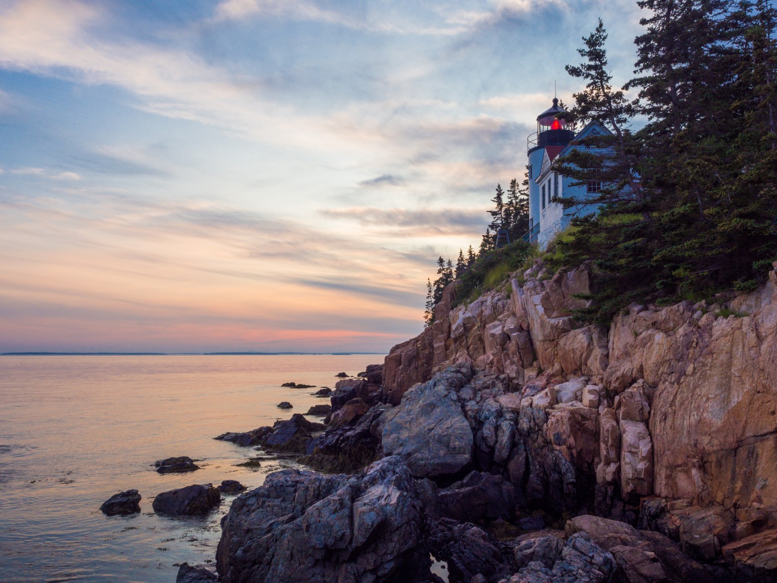
After returning to the hotel and resting a bit I notice that time is getting towards 8PM. You know what it means: we forgot about getting back to Thunder Hole at high tide 🙄. You know what else it means: sunset! We’ve been thinking about a sunset on Mt. Cadillac but now I think the mountain might actually block the harbor from the sun at this time and the view wouldn’t be that great. I have another place in mind that I think would be awesome in sunset (or in sunrise probably for that matter) – Bass Harbor Head Lighthouse.
Bass Harbor is a town on the other side of Desert Island and quite a bit of a drive away, but we should be able to make it in time. Driving through towns, however, is slow and there is a specific sign asking to slow down: “extra heavy hooves traffic”. It’s true – several White-Tailed Deer cross the road. We stop at another picturesque pebble beach across the roads from a lake.

Now whose white tail is there waving from the field of bushes?


We are just in time for a late sunset. I know there are stones with a nice view of the lighthouse to the left of it, and there is a pathway leading there. The path ends near the rocks already hosting at least a couple of dozen people, many with all kind of cameras and tripods 😲. Oh boy…

The view from the stones is absolutely delightful, but of course all the stone edges are already taken by sturdy tripods and their owners… With my shoulder bag I’m not ideally equipped for jumping on stones between people and puddles… I did my best and tried to get a picture by extending my arms high in the air. It’s hard to analyze it there and then… I didn’t quite get what I wanted, here is the result, still pretty good.


None of the people are going anywhere soon judging by the looks of them, and I understand – the sunset is not done yet, the golden hour is just beginning and the light will change – but I don’t want Toma and Anne to be bored and bitten by bugs, who are getting more active now. We get up to the lighthouse to look at it from the other side and then depart.

While waiting for me, Toma talked to a lady who was also waiting for somebody there. “Fifteen years ago there was literally nobody here,” she said. That’s the effect of the internet… I’m not complaining, oh no. Half the places we visited on this trip, we knew about because of the internet…

As a reward for us leaving early, there is a great sunset view of lakes and swamps along the way.


Night 9
Acadia National Park
We are back to the hotel but one thing enters our minds (mine and Tamara’s). One of the features of Acadia National Park is a very low light pollution. I have wanted for a long time to see the core of the Milky Way, really since our trip to Utah, where clouds interfered with that plan. Trying to do it here now has a low chance of success. First of all, it’s a bit far north: 44° 21′ (farther than 45° Milky Way core is not visible). Second – the moon is waxing gibbous, just past the first quarter, and that will interfere. But what’s the worst that can happen, we’ll see a starry sky? We have a flashlight and a tripod in the car, that can be a chance to use it. Anne is readily on-board with the plan… as long as we leave her be, sleeping 😅. OK, then. We start at midnight. First we try getting to the summit of Mount Cadillac.
Driving in total darkness is eerie. Some animals cross the road periodically. We see a White-Tailed Deer, a Porcupine and a Snowshoe Hare. Fortunately, our moose count did not increase on this drive.
The summit is windy and cold. We’re not alone, there are three or four cars parked here and I don’t know whether we should be surprised or not. The starry sky is indeed beautiful but hazy, the moon is still up and the Milky Way core is not visible. I’m thinking of making some starry sky pictures but there is really no context to it as the only thing visible is the sky. Maybe it will be better from the Sand Beach? It’s looking south, where Milky Way should appear (if it ever does), and while we’re driving the moon might be gone…
The moon is indeed almost gone by the time we parked at the beach, but still, no galaxy cores. Oh well, we tried. I install the tripod and spend some time making pictures when a couple arrives with sleeping bags. There is certainly enough space for everybody, but this is another proof: there are always people out and about in Acadia National Park.


Day 10
Acadia National Park
We saw the lighthouse yesterday, so today we are walking Gear Head Trail. It’s more difficult than Jordan Pond Trail but still isn’t challenging. I half expected to be bored after the spectacular Ocean Path, but there are nice views from Gear Head Trail to the Ocean Path and Sandy Beach from across the bay.


That’s not to say that Gear Head Trail doesn’t offer it’s own views on the other side, because it certainly does.


Back to the car, we are about to conclude our visit to Desert Island and Acadia National Park. One thing we definitely want to do is take a peek at the Thunder Hole, maybe now, in the afternoon, it is more active… Nope, still not quite there, I guess the high tide here is arriving later.
Getting out of Desert Island is not easy – lot’s of traffic. Looks like the times of easy scenic drives are about to end for us on this trip.
While on the road, after a bit of a research we decide to stop for the night in Belfast, Maine. Our way lies over
Penobscot Narrows Bridge

It is certainly a pretty bridge overlooking a picturesque river. One of the bridge stands has an observatory inside.
Belfast, ME
Our hotel has a decent looking restaurant where I order a lobster, forgetting for a moment that I have to deal with its dismemberment 😅. No humans were harmed during this dinner.

Our room has a balcony with a nice view…

Day 11
From here on we don’t really have a solid plan of what to see. We do want to see the some Maine towns, but which ones is up to us. Before the trip we thought it would be nice to visit a blueberry farm, but found that it’s still too early, maybe because of the late spring this year. At any rate we are already a short drive away from the center of
Belfast, ME
The marina is quiet in the morning, with just a few people around, a small group is surrounding a painter working on a landscape…

Our next stop is another town Down East that is currently west of us,
Camden, ME
But before going to the town center there is a park we would like to visit, Camden Hills State Park. In particular, it has a road leading to the summit of Mount Battie. More than a hundred years ago it was a place of a hotel and resort until a forest fire, while not destroying it physically, damaged the natural beauty enough to cause a complete decline of the business. The house was eventually torn down and a stone tower built in its place, but the carriage road to the summit remained (and got paved), enabling us to view the town and harbor from above with ease.


After enjoying the view and walking in a forest lets get to the town and see how it looks up close.
Turns out it looks quite charming. There is a marina and a park nearby. The streets are fairly crowded, though not nearly to the extent of Bar Harbor.


After walking around the town we select a restaurant at the marina, mainly for that very fact, as we can sit outside in a shade, enjoy fresh breeze and the view. The restaurant is not the best but the atmosphere is great.
Majority of the people around seem to be tourists taking some boat tours…
While today weather is excellent, showers are expected tonight and the weather tomorrow looks rainy. We are not too disappointed because, again, at this point our list of “must sees” is rather short. We are just going to head west while we can, and hopefully stay for the night near Portland.
We pass Wiscasset, which is considered one of the attractive Maine towns, and the view from the bridge is nice, but after Camden we are not super impressed and decide not to stop, but to reach Giant’s Stairs today instead. Giant’s Stairs is a stone formation located on the south tip of Bailey Island.
Bailey Island
The day is turning into evening. I’m not sure where the sun is, cause the sky is covered by clouds, and the further we drive into the peninsulas and the islands the thicker the fog gets. As we cross Bailey Island Bridge I have to stop the car because the foggy views are amazing in their tranquility.


As I learned later, by the way, the bridge we just passed is also called Cribstone Bridge and it’s build on the foundation of granite slabs without mortar or cement. Curious… I didn’t pay attention to that.
Going further and passing through another small village we have to just stop. This is the best view of a marina that we have ever seen. So serene in an evening fog, filled with small boats, with only an occasional bird flying by, it makes a stunning view.

We could sit here and look at it until darkness but we go further… Until finally the road ends with a sign that says simply “Land’s End”. There is no sign of what can be called “Giant’s Stairs”, just a small beach and a store.

Looks like we missed our turn again. We go back and finally find a sign to Giant’s Stairs (thank you Toma) and get to the shore via a tiny pathway through some bushes. After such a “giant” title, the stairs, frankly, look a bit small in my humble opinion, but then again, I’ve been recently spoiled by granite shores of Acadia National Park so…


Some of us (let’s not name names) refused to put on a jacket and is now getting cold under a chilly wind and a thick fog. The fog was noticeable before but now it is getting really heavy.

There isn’t much else to see plus it looks like rain is going to start very soon. We turn around.
Although it looks like it’s almost dark, it is not close to sunset yet. Our next stop is Portland, ME, which is not far, and, according to Toma, we shouldn’t need a lot of time there. Let’s go!
But first lets stop again near Bailey Island Bridge cause the views are still great.

Portland, ME
Our stop in Portland is extremely brief, both because of the approaching rain and because we didn’t really plan anything but a walk around the Old Port neighborhood. There are plentiful dining options around here but we are not hungry yet after our linner in Camden…


Day 12
The night was rainy and the day promises some precipitation as well. Of course, a visit to a farm, even without blueberries, is out of question, so the plan for today is still undecided. The plan for the morning, however, is set – lighthouses.
The first stop is the closer one, and it is
Portland Head Lighthouse
The lighthouse is a part of Fort Williams Park in Cape Elizabeth, along with remains of some military bunkers.
The morning is not rainy but it is quite foggy and, as our distance to the sea coast decreases, the fog thickness increases proportionally. By the time we’re there it is even thicker than it was yesterday.
Portland Head Lighthouse turned out to be the lighthouse, so to speak. I think if you search for pictures of “New England lighthouse” on Getty Images or something like that, a lot of them are going to be of Portland Head Lighthouse. It was on Tamara’s suggestion that we included this stop to our trip and I’m certainly glad we did.

The coast here looks familiar to Acadia, cased in granite stones.

Our next stop is Two Lights State Park, a park offering a view of two lighthouses… according to common sense. However, I miss my turn again because of the two signs near the same place: to the right – “Two Lights State Park”, to the left – “Lighthouses”.
It’s a good thing that the park has a paid entry so there is a lady in a booth that can enlighten us. To make long story short:
1) there are no lighthouses visible from the park (well, it does say 2 lights, not lighthouses 🤣)
2) there are 2 lighthouses that can be partially seen from a place not far from here if we turn left.
A place turns out to be a small parking lot in a residential area near one of the lighthouses, not a particular attractive one. No trace of the other lighthouse as far as I can see, and the parking lot is full anyway. Well, we sure feel even better about our visit to Fort Williams Park now…
Toma and Anne solved the rainy day problem very efficiently – we went shopping in Kittery Outlets. They enjoyed it, and a dinner (or, rather, a late linner, since there was no lunch) in Robert’s Maine Grill was very enjoyable.
Day 13
Salem, MA
Personally, I’m not a huge fan of witch stories and other fantasy stuff like that, although I do appreciate Harry Potter as a children book series, but we should at least stop here while Anne is still curious. Toma is also curious, probably because of the historical singularity and fame of the events. There have been so many religion driven murders throughout history though (and witch hunts belong in this category), that to me personally they do not seem very unusual.
We park and visit The Witch House, which is actually not a witch house, but rather a house of a judge, in fact one of the judges presiding over the witch trials in 17th Century. It is, however, a house of the right age, with the appropriate interior, basically a museum of 17th Century Massachusetts with information about the witch trials.

The curious thing about these trials (and subsequent executions) is that they appeared to be caused by hysterics of vengeful teenage girls. Literally almost all the accusers were teenage girls following the same pattern. Reading the story of the first accusations it’s quite surprising that more doubts in the gilt of the accused were not raised, which of course another reminder that, while the accusers were young girls, the judges and executioners were not. I knew enough about European history to realize that such designations of “Dark Ages” and “Renaissance” epochs are quite flexible in terms of place and time. Our Salem experience did not improve my opinion about the puritan New England.
We take a stroll around the area, on the streets with old houses, maybe not as old as the one we just visited, but still dating back to 18th Century.

We reject some suggestions from Anne to visit cheesy sounding places (we can watch movies at home) and settle on Salem Witch Museum. It’s a bit of a distance away but we elect to walk, which is good because the pedestrian-only center turns out to be charming (albeit touristy). We catch a bit of a group tour and learn some about Salem and its renown citizen, Nathaniel Hawthorne, author of “Scarlet Letter” and “The House of the Seven Gables.” Turns out Salem was a major port and one of the largest cities (technically, it was a town) in USA at one point (Wikipedia article lists it as #7 in 1790).
Witch Museum features a visual show consisting of static scenes, followed by a short guided tour about who “witches” were and the history behind them and witch hunts. I thought the tour was very good, though towards the end I thought the visual aids became childishly selective to the point of bordering with propaganda, but, to his credit, the guide didn’t use all of them.
All in all, it’s actually kind of cool to see an old town saying, collectively, yep, our ancestors here screwed up a long time ago, let’s acknowledge it and build a nice downtown with tourist entertainment, with an emphasis on how important it is to avoid such things from happening in the future.

Tomorrow will be the last day of our trip, and we have a plan to visit our relatives in Cherry Hill (a neighborhood in metropolitan Boston). Our visit to Boston this time will be very selective as we’ve been there before, and will go there in the future. Two things we plan to visit this time are New England Aquarium (Anne wanted to visit it) and Harvard Museum of Natural History (which we’ve never been to). After some deliberation we decide on the aquarium today and the museum tomorrow.
Boston, MA
Predictably, the traffic is bad. For me this is one of the things I start reminiscing already about Saguenay and New Brunswick. As soon as we left Acadia National Park the common road behavior patterns turned to worse all around, with the members of LLL (Left Lane Lovers) Club becoming numerous even in Maine. Massachusetts also adds the MySpace Road Association, people that feel no car should change a lane within 20 yards from them regardless of the reason or road situation. Basically, it feels pretty much like New York sometimes, maybe with a bit better roads. Come to think of it, Boston drivers are not any better than New Yorkers… Traffic situation near New England Aquarium is made more difficult by some sort of fair on Atlantic Ave. We finally park and get out. Boy is this area crowded!

Aquarium is no exception as it greets us with a gigantic ticket line under a hot sun! After 45 minutes of waiting we are finally in. To say it’s crowded inside would be an understatement 🙁. As Toma said, everybody and their mothers are here…
We watch a Sea Lion show, feeding of the Penguins, and spend some time in the Shark department.


It is surprising just how uncomfortable this place is on a hot crowded day, and it’s easy to see why. Its center piece is the giant cylindrical fish tank. Looking amazing and featuring many types of fish, it also means it is dark around. Well, today it means going through dark stuffy walkway almost entirely blocked by people and baby carriages, with noise levels of a stadium… during a rock concert… We walk around the aquarium and enjoy looking at the fish but that’s about all we can take this place for. We get out, take some pictures and have a linner at Legal Sea Food. I’m sure their sea food is really fresh but after Maine and Canadian sea food I wasn’t that impressed by their dishes. The ambiance of sitting outside is spoiled by loud buses and other tour vehicles constantly crawling about.

On the plus side, the hotel we’re in has HBO. I honestly don’t know whether it’s typical for a US hotel or not, but it just happens to feature a couple of movies we would like to see, so we do. Tonight selections are: “Bohemian Rhapsody” and “Fantastic Beasts: The Crimes of Grindelwald”.
Day 14
Cambridge, MA
We arrive about the time when Harvard Museum of Natural History opens and park right in front of it. The parking was so perfect in fact that we didn’t realize that we are right near the museum and started looking for it first. No way we could’ve found any parking around here yesterday, it’s a good thing we scheduled our visit for Sunday morning.
The museum has several very nice collections, including an extensive set of stuffed mammals, arthropods, glass flowers, fossils…

There is also a quite awesome collection of minerals, some of them huge in size. This room is the where we spent most of the time.


We go through the mammals section, which is quite extensive and densely packed, as opposed to, for example, American Museum of Natural History in NY, which spreads it around and makes it more picturesque.
Our trip ends with a visit to our relatives. We haven’t seen them for a long time and our gatherings are always great. One of Anne’s distant cousins is a girl one year younger and they have lots of fun, together with other kids.
In the evening the only thing to do is drive to New York. Amazingly, but not unexpectedly, the 4 hour drive doesn’t feel that long. I guess I got used to it… The total mileage of this trip turned out to be even more than I expected, just under 3000 miles! About three quarters of the Earth, if we go through it that is, or one eighth of the circumference.
It was planned as a hiking vacation, and it was, if you ask some members of our family, though I personally think we really did two real hikes, one in Saguenay and one in Fundy. Other walks were technically hikes as well, but for me they were just that, walks in nature… Which is great and I loved them, but probably not enough to call it a hiking trip. Well, if people call watching the birds “birding” why don’t we call our vacation “landscaping”? One thing for sure, we saw a lot of gorgeous landscapes on this trip. Time to process the pictures!
